
Trailhead: 5 miles south of Mammoth on the Old Bunsen Peak Road Trail
Distance: 8 miles (12.9 km) roundtrip
Level of Difficulty: Difficult
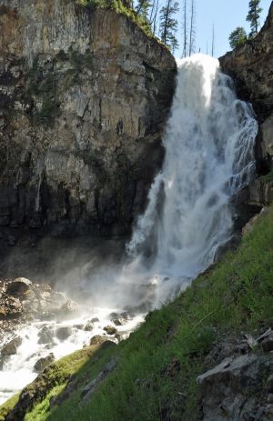
Whether you start south of Bunsen Peak on the old Bunsen Peak road (the trailhead noted above) or north of Bunsen Peak on the other end of the old Bunsen Peak road, you will be traveling about 2.5 miles along the road (now closed to automobiles) before you actually reach Osprey Falls Trail. From the south, the road starts out on level terrain and skirts Swan Lake Meadows after which point it inclines slightly as it curves behind Bunsen Peak. From the north, the old road travels through a small meadow where birds and waterfowl are often seen before it starts a steady climb up through a forested area on the back side of Bunsen Peak. This route offers good views of Sheepeater Canyon, and moose and deer can often be seen in the area. The actual Osprey Falls Trail starts at the rim of Sheepeater Canyon and drops some 800 vertical feet through a series of switchbacks to the floor of the canyon. From there, the trail follows the Gardiner River up to the base of the 150 foot falls. You can stand at the bottom of the falls and enjoy the spray of the waterfall, but be careful not to lose your balance on the wet, slippery (and sometimes icy) rocks.
The entirety of the hike to Osprey Falls via the old Bunsen Peak roadbed and back is about eight miles and is rated “difficult” by some trail guides. For an even more difficult outing begin your hike by ascending Bunsen Peak and descending down the backside of the mountain (the trail on the backside of the mountain is not as well used and you may encounter some deadfall across the trail at times) to the Bunsen Peak roadbed, turn left (northeast) and walk a short distance to the Osprey Falls trailhead. Ascending and descending Bunsen Peak on the way to Osprey Falls and returning to your car via the Bunsen Peak roadbed is about a ten mile outing.
Virtual View of Osprey Falls