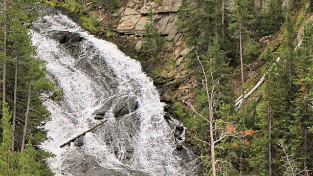
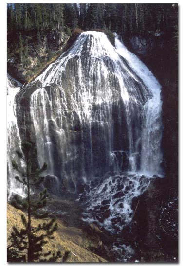
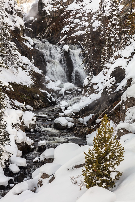
Virginia Cascades is located 2.5 miles east of Norris Junction on the Norris to Canyon road. It is located along a mile-long side drive to the south of the main road.
Brief Description
Virginia Cascades tumbles 60 feet over a relatively gradual slope into a deep canyon. The falls are just a few feet from the roadway, and there are only a few places in which automobiles can pull off the narrow roadway to observe the falls. It is a very beautiful waterfall not far from the mouth of a lush meadow, and surrounded by a thick strand of lodgepole pines.
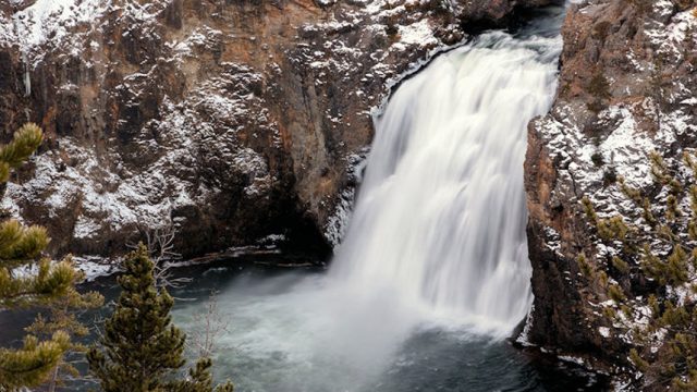
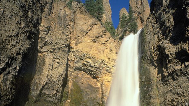
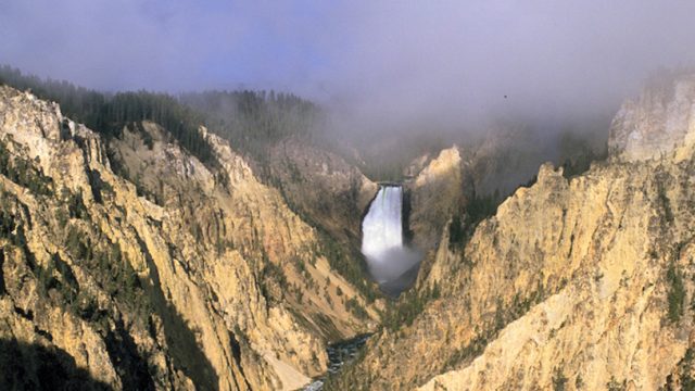
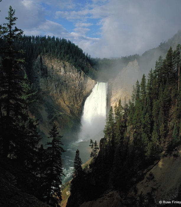
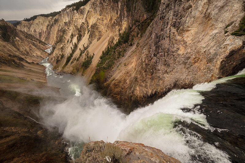
Upper Falls is located just south of Canyon village. Drive across Chittenden Bridge to Uncle Tom’s parking area to reach the trail head.
Brief Description and History
The Upper Falls of the Grand Canyon of the Yellowstone is neither as tall nor as popular as Lower Falls, but the 109 foot waterfall certainly merits a visit, as it is impressive in its own right.
This falls was called the “upper falls” for the first time by members of the 1869 Folsom party who estimated its height at 115 feet.
Visitors to the Brink of the Upper Falls have throughout time found the power of the experience worthy of detailed description. In 1870 N.P. Langford of the Washburn party wrote of his visit to the brink:
“Mr. Hedges and I made our way down to this table rock, where we sat for a long time. As from this spot we looked up at the descending waters, we insensibly felt that the slightest protrusion in them would hurl us backwards into the gulf below. A thousand arrows of foam, apparently aimed at us, leaped from the verge, and passed rapidly down the sheet. But as the view grew upon us, and we comprehended the power, majesty and beauty of the scene, we became insensible to the danger and gave ourselves up to the full enjoyment of it.”
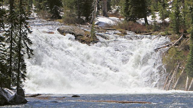
It is about 16 mile round trip. The trailhead is actually just outside the southern boundary of Yellowstone, near Flagg Ranch. Two miles south of the Park on US Hwy 287, turn west on Ashton-Flagg Road. After about a quarter of a mile, turn right. The paved road soon turns into a gravel road, and the trail starts just after crossing the spillway at the west end of Grassy Lake Reservoir. Two-wheel drive vehicles should park at the top of the dam and walk to the trailhead.
Brief Trail Description
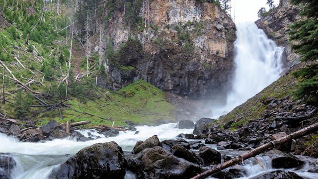
Union Falls, at 265 feet, is the second highest waterfall in Yellowstone (Lower Falls of the Grand Canyon is first at 308). The hike to it is not particularly strenuous, but is a bit long for a day hike. The waterfall is quite spectacular, and worth the hike.
Reader Contributions
“In my opinion, Union Falls is the most spectacular falls that I have seen in Yellowstone. I have seen a great number of the falls in the Park (Tower, Upper/Lower Yellowstone, Upper/Lower Colonnade, Fairy, Mystic, Osprey, Morning), and Union Falls surpassed them all. The incredible beauty of the two creeks coming together is worth the hike in. I would advise travel after August 1, when the level of the Falls River is low enough for safe crossing at the beginning of the hike (1/2 mile in). The NPS campground located near the Falls is also quite pleasant. There are two rivers that meet nearby: (1) the one coming from Morning Falls, at about 80 degrees in temperature, and (2) the one coming from Union Falls, at about 40 degrees. The only drawback is that fires are no longer allowed, and this is a grizzly zone. However, it is well worth the hike back to see.” — Contributed by Scott E. Reardon (Walla Walla, Washington)
Union Falls Trail Restoration
The highly popular Union Falls Trail is located in the south-central portion of Yellowstone National Park in the Bechler Sub-District. The Bechler area is historically known as “The Cascade Corners” of the Park due to the numerous waterfalls, pools, and cascades that can be found in the area. In addition to these attractions, many Park visitors are also drawn to the Union Falls Trail because it provides access to abundant berry patches, fishing opportunities, and colorful fall foliage. Unfortunately, in 2004, high water flooded a segment of trail approximately one mile south of the falls. This flooding resulted in extensive trail and resource damage. If left unchecked, the trail will deteriorate into a waterlogged area that will present a serious hazard to hikers and stock. If this happens, it is likely that trail users will seek drier adjacent routes thus fragmenting the main trail into multiple footpaths that further damage Park resources. The National Park Service Trails Crew will collaborate with Montana Youth Conservation Corps members to repair tread damage, install drainage and erosion control structures, and revegetate impacted areas.
Undine Falls is four miles east of Mammoth, near the roadway, and accessible by an easy, short hike.
Brief Description and History
Lava Creek spills over the cliff face of a basalt lava flow that was emplaced about 700,000 years ago. The falls is approximately 60 feet in height, descending in three plunges.
Originally called “East Gardner Falls,” “Cascade Falls of the East Gardiner,” or “Gardiner River Falls,” Undine received its present name in 1885 from geologist Arnold Hague. Undine (Webster says it is pronounced UN deen) was named for wise, usually female water spirits from German mythology who lived around waterfalls and who could gain souls by marrying mortal men.
Undine Falls was featured on the cover of the July 1977 edition of National Geographic magazine.
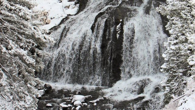
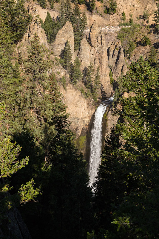
Tower Fall is 17 miles north of Canyon or two miles south of Roosevelt. During the winter months, the frozen falls are accessible via cross country skies.
Brief Description and History
Tower Fall is a must see waterfall. 132 feet in height, the waterfall is located in a canyon near the Tower Falls general store. A half-mile steep, switchback hike downward takes you to the bottom of the waterfall. Take the same trail back up. The trail is also accessible during the winter months, but skiers should pack in shoes appropriate for descending the very icy trail. During the winter months, the entire waterfall is encased in an ice dome. The name “Tower” is derived from the towering volcanic formations surrounding the falls.
Trailhead: 5 miles south of Mammoth on the Old Bunsen Peak Road Trail Distance: 8 miles (12.9 km) roundtrip Level of Difficulty: Difficult
How to Get There and Brief Description
Osprey Falls is located behind Bunsen Peak. The main route to Osprey Falls (noted above) begins at the old Bunsen Peak roadbed near the Bunsen Peak trail head located south of Bunsen Peak and five miles south of Mammoth. Follow the flat to slightly-inclined road bed for 2.5 miles as it curves around Bunsen Peak to the east. The Osprey Falls trail head is marked and is on the east side of the road bed. Osprey Falls is set deep in Sheepeater Canyon and is about 150 feet high. From the roadbed the hike to the base of the waterfall descends 800 feet in a series of steep switchbacks. The entire hike to Osprey Falls and back is 8 miles and is rated as “difficult” by some trail guides.
Whether you start south of Bunsen Peak on the old Bunsen Peak road or north of Bunsen Peak on the other end of the old Bunsen Peak road, you will be traveling about 2.5 miles along the road (now closed to automobiles) before you actually reach Osprey Falls Trail. From the south, the road starts out on level terrain and skirts Swan Lake Meadows after which point it inclines slightly as it curves behind Bunsen Peak. From the north, the old road travels through a small meadow where birds and waterfowl are often seen before it starts a steady climb up through a forested area on the back side of Bunsen Peak. This route offers good views of Sheepeater Canyon, and moose and deer can often be seen in the area. The actual Osprey Falls Trail starts at the rim of Sheepeater Canyon and drops some 800 vertical feet through a series of switchbacks to the floor of the canyon. From there, the trail follows the Gardiner River up to the base of the 150 foot falls. You can stand at the bottom of the falls and enjoy the spray of the waterfall, but be careful not to lose your balance on the wet, slippery (and sometimes icy) rocks.
The entirety of the hike to Osprey Falls via the old Bunsen Peak roadbed and back is about eight miles and is rated “difficult” by some trail guides. For an even more difficult outing begin your hike by ascending Bunsen Peak and descending down the backside of the mountain (the trail on the backside of the mountain is not as well used and you may encounter some deadfall across the trail at times) to the Bunsen Peak roadbed, turn left (northeast) and walk a short distance to the Osprey Falls trailhead. Ascending and descending Bunsen Peak on the way to Osprey Falls and returning to your car via the Bunsen Peak roadbed is about a ten mile outing.
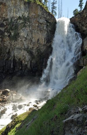
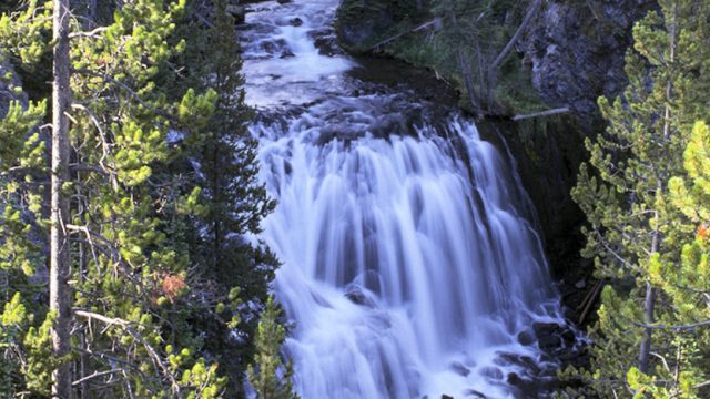
The falls are located behind Biscuit Basin, near the Old Faithful Area. After about .5 miles, the trail takes a fork. The left-hand fork goes directly to Mystic Falls and is about one mile long. It is an easy hike. The right-hand fork also goes to the Falls, but is nearly two miles long and is uphill the first half-mile. A great view awaits at the top of the ridge. The entire loop is about three miles long.
Brief Description
For those who love waterfalls in particular, one of the best short waterfall hikes is Mystic Falls. The longer route offers a fantastic view of the Upper Geyser Basin (Old Faithful Area) and the ridgeline which runs to the west. Mystic Falls itself is a spectacular waterfall which cascades about 70 feet down off the Madison Plateau along the Little Firehole River. It is a bit unique among Yellowstone’s waterfalls in that thermal activity is visible from the bottom all the way to the top of the falls, with clouds of steam rising from seemingly dozens of places at the top, sides and bottom of the waterfall. Although one will likely encounter other hikers on the trail, the Mystic Falls trail is one of Yellowstone’s many quick getaway trails.
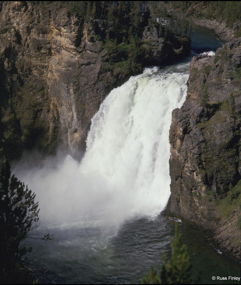
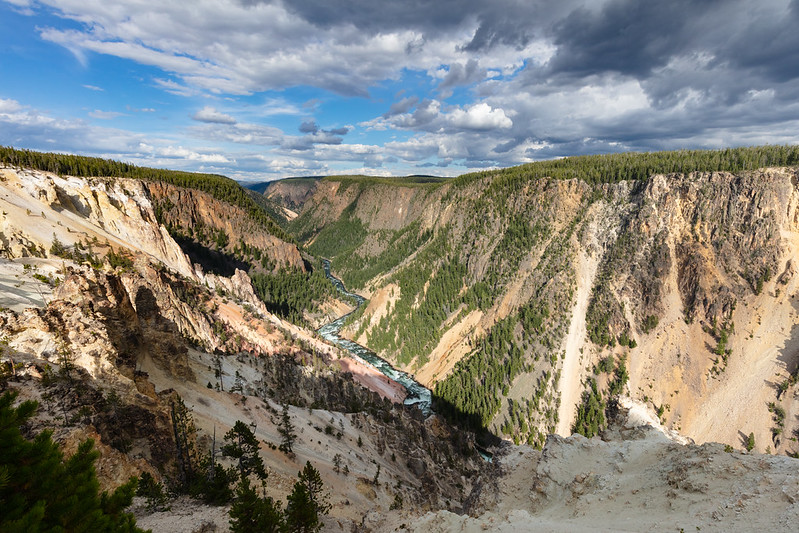
The Lower Falls area is located just to the east of Canyon Village. A one-way loop drive takes you to the brink of the Grand Canyon and offers four views, with the last stop at the trail that leads to the top of the Falls.
Brief Description
Lower Falls, the biggest waterfall in Yellowstone, is the most famous in the Park, hands down. In fact, the 308-foot tall waterfall it is most likely the second most photographed spot in Yellowstone, with Old Faithful Geyser being the first. There are numerous views of the Falls from both the east (Inspiration Point, Grandview Point and Lookout Point) and west (Artists Point) sides of the Grand Canyon, most of which require only a short walk or virtually no walk to see. The trail to the top of the Falls (3/4 of a mile roundtrip, but steep with many switchbacks) is a must, as the experience of standing atop the Falls is one of the most breath-taking experiences in the entire Park.
The canyon’s colors were created by hot water acting on volcanic rock. It was not these colors, but the river’s yellow banks at its distant confluence with the Missouri River, that occasioned the Minnetaree Indian name which French trappers translated as roche jaune, yellow stone. The canyon has been rapidly downcut more than once, perhaps by great glacial outburst floods. Little deepening takes place today.
View from Inspiration Point
Inspiration Point
A member of the Washburn party in 1870, Nathanial P. Langford, used these words to describe his visit to this point:
“The place where I obtained the best and most terrible view of the canyon was a narrow projecting point situated two to three miles below the lower fall. Standing there or rather lying there for greater safety, I thought how utterly impossible it would be to describe to another the sensations inspired by such a presence. As I took in the scene, I realized my own littleness, my helplessness, my dread exposure to destruction, my inability to cope with or even comprehend the mighty architecture of nature.”
Lookout Point
Lookout Point
This was a popular lookout for many early visitors to the park. Noticing that it got regular visitation, in 1880 Superintendent P.W. Norris built a railing here and the location has been called Lookout Point ever since. It is likely that this was the superintendents preferred name for the spot. It had been called many things prior to 1880 including Point Lookout, Lookout Rock, Mount Lookout, and Prospect Point.
Brink of the Lower Falls
Over the years the estimates of the height of this falls has varied dramatically. In 1851 Jim Bridger estimated its height at 250 feet. One outrageous newspaper story from 1867 placed its height at “thousands of feet”. A map from 1869 gives the falls its current name of Lower Falls for the first time and estimates the height at 350 feet.
It mattered little how tall the observers thought the falls was. They consistently write journal entries that comment on its awe-inspiring nature. A member of the 1870 Washburn party N. P. Langford gave this brief but poetic description: “A grander scene than the lower cataract of the Yellowstone was never witnessed by mortal eyes.”
Reader Contribution
“Without hesitation I would say that the Lower Falls is by far my favorite waterfall in Yellowstone. Lower Falls is both breath-taking and beautiful as well as extremely powerful and commands a great amount of respect. The truly great aspect to Lower Falls is the ability to see it from several distinct vantage points. One can view the falls in a quiet solitude from Artist Point as the water drops 308 feet into the mist below or journey to the top of the falls and feel its extreme power, commanding respect, and intense roar as it drops into the rainbow of mist beneath. Uncle Tom’s Trail as well as the North Rim Trail both offer spectacular sights too. The Lower Falls below a full moon night cannot be forgotten. When the moon is so bright that it seems like daylight, the canyon’s rocky walls are illuminated a pasty yellow, white, orange, and a hint of red. In the distance Lower Falls can be heard plunging its’ 308 feet into the darkness as the moon continues to shine. Another aspect of Lower Falls which is so beautiful and intriguing is the powerful rumble in produces even at unseen distances. When I arrived within the borders of Yellowstone in May of 1998 the Lower Falls was my first destination. As I walked the ‘P’ trail, which connects the Canyon lodges to Grandview lookout, I had butterflies in my stomach as I turned to see the majesty of the Lower Falls once again. And then I heard its faint rumble as I turned a corner and I was in ecstasy.” — Justin Mattson is from Wheaton, Chicago. He has traveled most of the lower United States, and has been to Yellowstone three times.
Located roughly 11 miles inside Yellowstone’s south entrance, and two miles south of Lewis Lake, Lewis falls is easily accessible from parking lots on each side of the Lewis River bridge.
The falls are about 30 feet in height.
Lewis Falls Trail Rehabilitation
Located 10 miles north of Yellowstone’s South Entrance, the Lewis Falls Trail is an easily accessible path which leads to a dramatic overlook of the Lewis River Falls. Last year, more than 700,000 visitors passed through the South Entrance gates and many of these visitors stopped to walk the Lewis Falls Trail, picnic near the falls, or fish in the river. The trail is also very near to the popular Lewis Lake campground where more than 15,000 campers stay and recreate each summer. Because of the high visitor impact in this area, many new trails have formed and much damage has occurred to the vegetation within these trail corridors. This project will focus on repairing the deteriorated main trail so that it is safer, easier to use, and more clearly delineated. The National Park Service trails staff, in partnership with the Montana Youth Conservation Corps, will spend four weeks building masonry steps, installing soil retention and drainage mechanisms, and rehabilitating impacted soils, bared tree roots, and vegetation along the length of this trail.
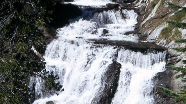
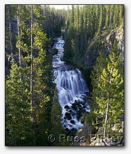
Kepler Cascades is located about two miles south of Old Faithful Village. The cascades are viewable from a roadside pullout.
Brief Description and History
This three-tiered cascade drops over 50 feet as the Firehole River flows North. The Kepler Cascades were actually named in 1881 for the 12 year old son of Wyoming’s territorial governor, Kepler Hoyt, who toured the park with his father, Governor John Hoyt.
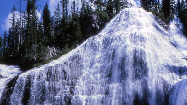
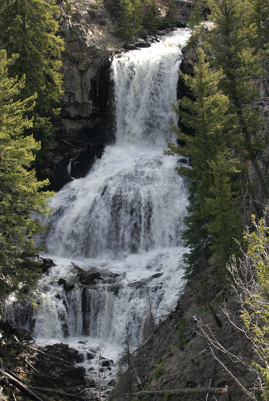
 Kepler Cascades is located about two miles south of Old Faithful Village. The cascades are viewable from a roadside pullout.