search expand
Skip to content
  • HOME
  • Intro
  • Maps
  • Webcams
  • Geysers
  • Wildlife
  • Geology
  • Lodging
  • Camping
  • Hiking
  • History
  • News
  • Videos
  • More Links
  • Maps HOME
  • Official Park Map
  • Relief Map
  • Terrain Map
  • Roads Status
  • Get Directions
  • Park Area Maps
    • Old Faithful Area Map
    • Canyon Area Map
    • Mammoth Area Map
    • Fishing Bridge/Lake Area Map
    • West Thumb Area Map
    • Mileage Map
  • Services Map
  • Topo Map
  • Winter
  • Google Street Views
    • Interesting Yellowstone Street Views
    • West Entrance to Madison Jct.
    • Madison Jct to Old Faithful
    • Old Faithful – West Thumb
    • West Thumb to South Entrance
    • West Thumb to Fishing Bridge
    • Fishing Bridge to Canyon
    • Canyon to Tower Jct
    • Tower Jct to Cooke City
    • Tower Jct to Mammoth Hot Springs
    • Mammoth Hot Springs to Gardiner
    • Mammoth Hot Spring to Norris Jct
    • Norris Jct to Madison Jct

Yellowstone Maps

A collection of helpful Yellowstone Maps

Tower Jct to Mammoth Hot Springs

Posted on March 5, 2011July 23, 2022 by siteadmin

Tower Jct to Mammoth Hot Springs
Select a new starting point – Links will open in above window
Leaving Tower Jct
Floating Island Lake
Near Geode Creek
Blacktail Ponds
Crossing Yellowstone River
Approaching Mammoth Hot Springs

Click on any road section for more.

west to madison madison to old faithful old faithful to west thumb west thumb to south entrance west thumb to fishing bridge fishing bridge to east entrance fishing bridge to canyon canyon to tower tower to northeast entrance tower to mammoth mammoth to norris mammoth to gardiner norris to madison norris to canyon

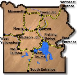
This section of road is open year round and passes over the Blacktail plateau before it descends into Mammoth Hot Springs.

Posted in Street Views

Post navigation

Previous PostCanyon to Tower Jct
Next PostTower Jct to Cooke City