search expand
Skip to content
  • HOME
  • Intro
  • Maps
  • Webcams
  • Geysers
  • Wildlife
  • Geology
  • Lodging
  • Camping
  • Hiking
  • History
  • News
  • Videos
  • More Links
  • Maps HOME
  • Official Park Map
  • Relief Map
  • Terrain Map
  • Roads Status
  • Get Directions
  • Park Area Maps
    • Old Faithful Area Map
    • Canyon Area Map
    • Mammoth Area Map
    • Fishing Bridge/Lake Area Map
    • West Thumb Area Map
    • Mileage Map
  • Services Map
  • Topo Map
  • Winter
  • Google Street Views
    • Interesting Yellowstone Street Views
    • West Entrance to Madison Jct.
    • Madison Jct to Old Faithful
    • Old Faithful – West Thumb
    • West Thumb to South Entrance
    • West Thumb to Fishing Bridge
    • Fishing Bridge to Canyon
    • Canyon to Tower Jct
    • Tower Jct to Cooke City
    • Tower Jct to Mammoth Hot Springs
    • Mammoth Hot Springs to Gardiner
    • Mammoth Hot Spring to Norris Jct
    • Norris Jct to Madison Jct

Yellowstone Maps

A collection of helpful Yellowstone Maps

Canyon to Norris

Posted on October 4, 2021June 24, 2022 by siteadmin

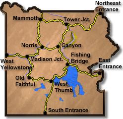
Select a new starting point – Links will open in above window
Leaving Canyon Jct
Along the road
Ice Lake Trailhead
Virgina Cascades Road
Crossing Gibbon River
Approching Norris Jct

Click on any road section for more.

west to madison madison to old faithful old faithful to west thumb west thumb to south entrance west thumb to fishing bridge fishing bridge to east entrance fishing bridge to canyon canyon to tower tower to northeast entrance tower to mammoth mammoth to norris mammoth to gardiner norris to madison norris to canyon

This section of road is a crossover to the other side of the Park. It reaches an elevation of 8,257ft. The road passes by the turn of the Virginia Cascades Drive.

Posted in Street Views

Post navigation

Previous PostWest Thumb to South Entrance
Next PostInteresting Yellowstone Street Views