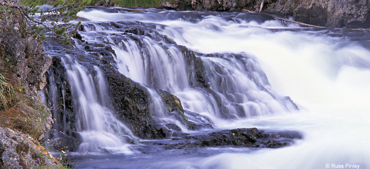
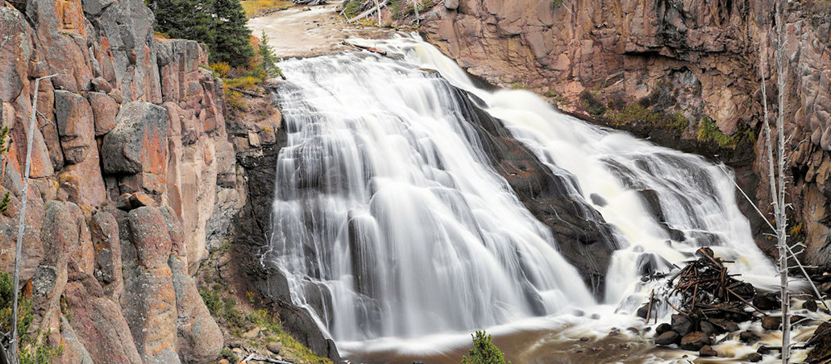
GIBBON FALLS

gibbon falls

How to Get There and Brief Description Gibbon Falls is located on the Gibbon River about midway between Norris Geyser Basin and Madison Junction.  The falls are situated where the Gibbon River falls off the Northern escarpment into the Yellowstone Caldera. There is a parking area near the top of the falls which offers a … Read more

FIREHOLE FALLS

Firehole Falls

How to Get There and Brief Description Located one-half mile south of Madison Junction, Firehole Falls is alongside the Firehole Canyon Road.  This one way drive runs north to south, and features steep canyon walls in addition to the waterfalls.  The falls themselves are about 40 feet in height.  During spring and early summer, Firehole … Read more

FAIRY FALLS

Fairy Falls

How to Get There Fairy Falls can be reached from two different trailheads. The first trailhead, 1 mile south of the Midway Geyser Basin, begins at a steel bridge across the Firehole River and follows the Fountain Freight Road hiking/biking trail for approximately 1 mile before the hiking-only trail to Fairy Falls branches off on … Read more

YELLOWSTONE RIVER PICNIC AREA TRAIL

Trailhead: 1.25 miles  NE of Tower Junction on the road to the NE Entrance Distance: 3.7 miles (5.9 km) roundtrip Level of difficulty: Moderately strenuous A moderate trail which starts at the Yellowstone River Picnic Area and rises up to the eastern lip of the Grand Canyon of the Yellowstone, following the rim of the … Read more

WRAITH FALLS TRAIL

Trailhead: Pullout ¼ mile east of Lava Creek Picnic area, Mammoth-Tower RoadDistance: 1 mile (1 km) round tripLevel of Difficulty: Easy This short, easy hike takes only minutes.  It travels through open sagebrush and Douglas-fir forest to the foot of Wraith Falls cascade on Lupine Creek.  It is a good option for families with young … Read more

UPPER GEYSER BASIN TRAILS

Trailhead: Boardwalk in front of Old Faithful Visitor CenterDistances: Several miles of trails, including a loop to the east and one to the westLevel of Difficulty: Easy Although Old Faithful Geyser, the most famous geyser in the park, is located in this area, the trails oriented around Old Faithful Village offer the opportunity to see … Read more

STORM POINT TRAIL

Trailhead: Pullout at Indian Pond, 3 miles east of Fishing Bridge Visitor CenterDistance: 2 mile (3 km) loopLevel of Difficulty: Easy   If you would like to get a good view of Yellowstone Lake off the beaten path, without expending much effort, this could be the trail for you. This easy trail starts at the … Read more

SPECIMEN RIDGE TRAIL

Specimen Ridge

Trailhead: 2.5 miles east of Tower JunctionDistance: 1 to 11 miles one wayLevel of Difficulty: Moderate to DifficultThis is a moderate trail which takes one to the lip of the Grand Canyon of the Yellowstone at the one mile point, then turns to the east and gradually climbs through sagebrush and grassy meadows, reaching the … Read more

SOLFATARA CREEK TRAIL

Trailhead #1: Loop C in Norris Campground Trailhead #2: approx. 3/4 mile south of Beaver Lake Picnic Area Distance: About 13 miles round trip Level of Difficulty: Easy to moderate; highest climb is about 400 feet Beginning in the Norris Campground, the trail traverses lodgepole pine forest as it follows Solfatara Creek for a short … Read more

PELICAN CREEK TRAIL

Trailhead: West end of Pelican Creek Bridge, 1 mile (1.5 km) east of Fishing Bridge Visitor CenterDistance: 1 mile (1.5 km) loopLevel of Difficulty: EasyThis very short but scenic trail passes through a forested area to the shore of Yellowstone Lake before looping back across the marsh along Pelican Creek to the trailhead.  The trail … Read more